
(LINKS
TO PAST FOSSIL FRIDAYS)
Community College (LRCCD)
Geology & Earth
Science Instructor: Arthur Reed, P.G.
Happy
Fossil Friday!
Friday October 16, 2020
Instructor: Arthur Reed, P.G.
Seafloor
Fossils on the Summit of Mt. Everest?
Earth
is Dynamic!
The
summit of Mount Everest, the highest point on Earth, is an ancient sea
floor. It is limestone with fossils of trilobites, crinoids, brachiopods,
ostracods, and others...all life from an ancient ocean floor. The rocks
at the top of Mt. Everest (where climbers spend a fortune to stand) formed from
sediment on the floor of the ancient Tethys Sea (or possibly a pre-Tethys Sea)
in the range of 450 million years ago. Its floor was pushed up into the
Himalaya Mountains by India colliding with Asia in the process of plate
tectonics starting around 55 million years ago.
See Full Article Below
Fossils of Mount Everest

The summit of Mount Everest, the
highest point on Earth, is a sea floor. That may come as a surprise; after all,
a sea should be at sea level. In practice, there is some flexibility on this.
Three seas are below sea level: the Dead Sea, the
Salton Sea and the Caspian Sea. All are salt water lakes
which carry the name sea. There is a fourth one, the Aral Sea, which is above
sea level. Its water surface (at least what remains of it, after one of the
biggest environmental disasters of the 20th century) is
currently 42 meters above sea level, and it can therefore claim to be the highest
salt-water sea on Earth. It is still some way off Everest though. There is one fresh water lake which is called a ‘sea’: the Sea of
Galilee, but it is also below sea level. Lake Baikal is called ‘sea’ by the locals, but not
in its official name – if it did, it would have been the highest sea on Earth, at
455 meters. The highest fresh-water lake on Earth is reported to be the crater
lake of the Argentinian volcano Ojos del Salados which
is at 6930 meters. However, it is rather small, at 35 meters, and by definition should be called a pond rather than a lake. Cerro
Tipas Lake at 5950 meters is the next best candidate.
There are some higher bodies of water in the Himalayas
but they are ephemeral. But every single one of them is topped by the summit of
Everest. It is perhaps a bit sobering to think that people who sacrifice their fortune
and potentially their lives in order to climb Mount
Everest, end up standing on a sea floor.
A sea floor should be lower than the sea it
floors. Clearly, things have happened here that turned a sea floor into the
roof of the world. The story behind this involves the highest fossil hunting on
the planet, and not one but two lost oceans. It shows how trilobites managed to
beat Nepal’s famous Sherpas, by hitching a ride with a carrier, becoming cargo
to the mountain itself.
The presence of marine fossils near the summit
of Mount Everest has entered the domain of common knowledge. Many posts,
articles, and newspapers state that sea shells are
found at the summit. But few give the source of their information – it is just
something that ‘everyone knows’. And there is confusion about the fossils of
Mount Everest. Shells are commonly mentioned, of varying sizes. A few sites
mention ammonites, and I even found one that claimed the presence of fish. Try
to find the source of their information and you quickly hit blanks and dead
links. Who did the fossil collecting? Most people climbing Mount Everest do not
go there to hunt for fossils. Their goal is to reach the summit – not to bring
down the mountain. On the way up, you don’t want to
carry rocks with you. On the way down, your main aim is staying alive, while
frozen and oxygen-deprived. Where are the fossils of
Mount Everest? And what are those fossils?
Facts

First, let’s
clear up some confusion. How did a mountain shared between Tibet and Nepal end
up with an English name? You can blame the Royal Geographical Society for that.
This was the age of the exploration, and what is the point of exploring if you can’t give names? Marquez’ master piece, One hundred years of solitude, describes when the world was so recent that many
things lacked names, and in order to indicate them it was necessary to point. This was not
the British way. Names were needed. Mount Everest had not been noticed at first
as being particularly impressive. The exploring had to be done from a
considerable distance, from Tibet, as the explorers were not allowed entry into
Nepal. Foreshortening meant that other peaks appeared taller. In the 1840’s,
the first indications appeared that a distant peak could be taller than any
other. For a while it was called ‘peak b’, and later it became ‘peak XV’, but
that wouldn’t do. When no local name could be
identified, it was finally named after George Everest, Surveyor General of
India. The pronunciation evolved, with the long ‘e’ becoming a short one, but
otherwise the name stuck. The new pronunciation had a ring to it: it sounded
like a special place.
However, unbeknown to the explorers, a Tibetan
name was already in existence. It was Qomolangma, and
that name is now often used. Nepal has since adopted yet a different name,
Sagar-Matha. Pick your choice: whichever name you
use, at least you no longer have to point.
And what about the height? Nepal and China,
who share the summit, quote different numbers for it. Nepal uses the
traditional 8848 meters. China claims it is only 8844 meters. The first number
refers to the actual altitude climbers reach when standing (very briefly –
there is a queue) at the summit. They are standing on 3-4 meters of snow. The
second number gives the rock height which is a more stable way to measure a
mountain – but it isn’t as high so it didn’t catch on.
People who climbed the mountain from the Tibetan side would find their
achievement listed as 4 meters less than those climbing the same mountain from
Nepal. When spending a fortune, such details matter.
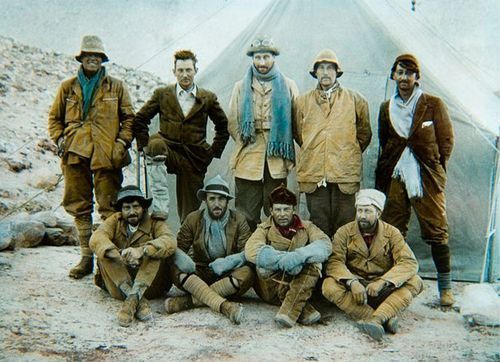
The 1924 Everest expedition. Back row, left to right: Andrew Irvine,
George Mallory, Edward Norton, Noel Odell, and John Macdonald. Front row:
Edward Shebbeare, Geoffrey Bruce, Howard Somervell,
and Bentley Beetham.
But regardless of the name and
the height, Mount Everest is a very dangerous mountain.
The sheer number of people climbing it in the brief annual climbing season does
not help. But the statistics of the mountain are sobering. For the Sherpas, the
fatality rate is between 1% and 4% per year. Avalanches
during the pre-season preparations are especially deadly. Almost 300 people
have died on Mount Everest since 1950. Among them is the NASA astronaut and
astronomer Karl Henize – but many other names could
be mentioned. George Mallory, who disappeared near the summit together with
Irvine in 1924, was born very near to where I now
live. The chase of Everest connects the world.
The layers of Everest
The triangular mountain is
instantly recognizable. If you haven’t studied the shape in detail, try
this gigapixel view. But it is easy to miss the detail in the
mountain. There are several layers. For instance, there is a region with inclined
layered bedding, a bit below the summit, clearly visible at the bottom of the
summit pyramid.

The second most famous pyramid in the world
The structure of the mountain is a bit hidden
behind the snow. Sweep the snow away, and four main layers appear. The same
layers are also visible in the other mountains in the area.

Source: http://www.earthsciences.hku.hk/shmuseum/earth_evo_08_2.5.2.5.php RF:
Rungbok formation; ES: Everest Series; YB: Yellow Band;
OF: Qomolonga Formation (Everest limestones)
The layers are colour-coded
in the drawing shown here. The bottom layer is colour-coded
in brown, and labelled ‘LG+RF’. ‘RF’ stands for Rungbok Formation and ‘LG’ is a granite. RF is a gneiss:
rock partly melted and metamorphosed under high temperatures (up to 500 C) and
pressure, deep below the mountain. The granite was molten crustal rock from
below which pushed its way up into this layer, much like granite complexes have
done at the heart of every mountain chain. A low-angle (almost horizontal)
fault separates the layer from the one above, which is colour-coded
in green. This layer is called the Everest Series (ES), and it consists of
sedimentary rock which has been metamorphosed at reasonably high temperatures.
Above this, in yellow, is the so-called ‘Yellow Band’. This is the layered
bedding which was mentioned before. It is a limestone, formed from a shallow
marine sediment, heated to become a marble. Above this is another
near-horizontal fault, and above this is an almost unmetamorphosed layer of
limestone here called ‘QF’ for Qomolangma Formation,
which forms the summit of Everest. The layers have moved around: the two faults
are planes along which the layers have been sliding into their current
position. The upper layers didn’t form exactly here,
nor did they form in the same place. They are short-distance migrants.
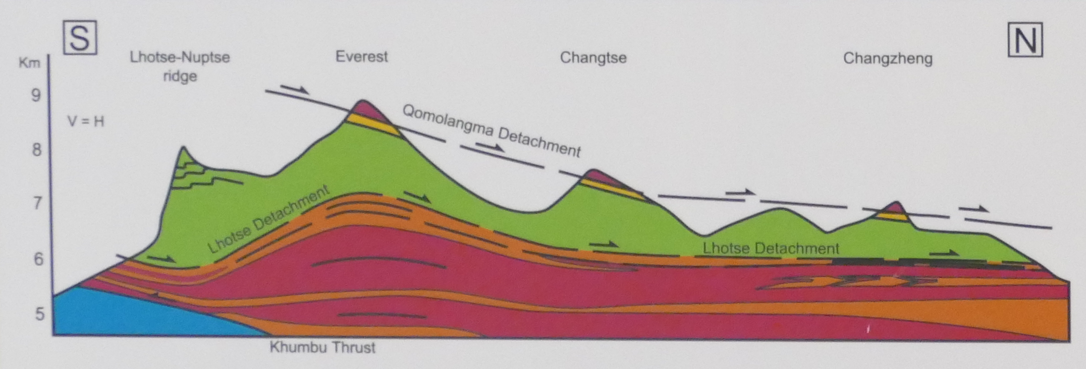
Look at nearby mountains, and the same layers
may be seen in the same order, although not at the same altitude. From south to
north, the layers decline in altitude. The mountain building that pushed them
up in the first place, caused by crustal thickening and intrusion of the
granite, was strongest around Mount Everest but less severe further north. The
fact that the layers don’t invert shows that in this
location, the sliding was a simple process. There was no turn-over of layers as
happened elsewhere, and as is seen in the Alps or Caledonian mountains. Around
Everest, the upper sediment that has been least metamorphosed is always at the
top. But few mountains are high enough to reach them: in most cases, erosion
has removed this layer completely. There are nine mountains over 8 kilometer
high in the high Himalayas. Of those, 6 still have a sedimentary layer at the
top.
The Tethys Ocean
The top layers of Mount Everest are made from
a marine sediment: a sea floor. But which sea? Or rather, which ocean? To
answer this, we need to go back to the heady days when the Himalayas formed.
The Himalayas were a long-delayed
consequence of the break-up of Gondwana. Australia, Africa, South America, India and Antarctica were all together in this
supercontinent. (The world rugby competition between Gondwana and its
northern-hemisphere counterpart, Laurussia, must have been a very one-sided
affair!) Gondwana began to break up along the east coast of Africa where a fault grew into the Indian
Ocean. In the process, a fragment was split off and became adrift in this new
ocean. The fragment split further, into Madagascar and India. Madagascar stayed
behind, but the fault behind India rapidly widened into an ocean and India was
pushed forward, north. Between India and Asia was the Tethys: a worldwide,
equatorial ocean running from China to Central America.

So India went across,
closing the Tethys in the process and forming the Indian Ocean behind it. The
seafloor that was uplifted and shifted to Everest was from the Tethys. It wasn’t the deep ocean basin: that was mostly subducted. The
mountains grew from the continental shelf, and pushed
up the sediment that was lying on it. The Tethys just disappeared. A few scars
remain which trace the lost ocean. Some have already been mentioned: the Black Sea, the Caspian Sea and even the Aral Sea trace
out the line where the ocean once was.
This is the basic view, In
reality, things were a bit more complicated. I’ll come
back to that.
Collision
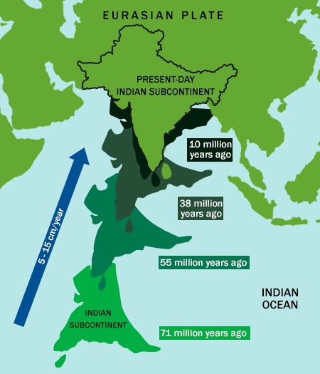
50 million years ago India completed the
crossing, failed to stop, and crashed into Asia. The collision happened in two
phases. First, India hit an island chain. This was a volcanic island arc that
had grown out of the subduction zone. The island arc left its sign in northern
Pakistan. Later, India hit Asia, beginning in the northwest
and ending in the northeast, in a drawn-out process. Originally, India had
moved at break-neck speed, covering the distance at up to 20 cm per year. By
the time of the initial collision, India had slowed down to 5 cm per year. This
was still well above the speed limit for safe continental docking, though. The
continental plate of India slid underneath Asia, and crumpled.
The Himalayas are the crumple zone of that collision. The granite that forms
the heart of the Himalayas consists of the Indian plate, melted at the high
pressures at the bottom of a crust thickened to 70 kilometers.
The collision left India a lot smaller than it
used to be. At 5 cm per year, India has lost 1000 kilometers over 20 million
years. And still it is moving. It is hard to stop a continent.
So the Himalayas grew
from below. In the process they pushed up the layer of seafloor sediment. Once
the new mountains pulled in the rains, erosion attacked them. It removed the
material from the top. In consequence, very little of the old seafloor that
formed the upper reaches remains: only those 6 of the
highest peaks just reach the Tibetan marine deposits. The rest of the old sea
floor has been carried away by the giant rivers of the Himalayas,
and returned to the Indian Ocean.
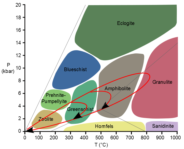
Fossils
The ancient sea floor will have
incorporated the organic remains of ocean life. Fossils are relatively fragile:
they can survive a modest amount of heating of the rock, although it may push
then out of shape. But there are limits. You expect fossils in sedimentary
rocks and in mildly processed metamorphic rock. By the time the rock
becomes greenschist, any fossils will be gone.

A schist from high up on Mount Everest. Source: https://palaeomanchester.wordpress.com/2017/12/14/reaching-new-heights-with-collecting-everest-specimen/ It
was collected at around 8 km altitude and that is impressive enough. But it is a
schist and as such contains no fossils.
The lower layers of Everest are indeed greenschist, and are not great for fossils. The granite was
injected from below and has been through worse: no fossils here. The Yellow
Band is a marble, heated enough that only microscopic fossils may be left. The
upper-most layer is limestone and although it has seen elevated temperatures
and pressures, it remains suitable for fossils – if you don’t
expect too much! It is found above 8600 meters.
The most interesting fossil rock of Everest
will therefore be those nearest the summit. But they are also the hardest to
get hold off. You can’t just jump on a plane to go
collect an Everest summit rock! Luckily, we don’t entirely
depend on the mountain itself: because the layers tilt downward towards the
north, the same (or similar) rocks can be collected at slightly more reasonable
altitudes. The Rongbuk Glacier in Tibet is such a
place, and a lower layer is named after this location. But in the end, the
fossil scientists wanted rocks from the mountain itself.
The first rocks from the upper layers were
collected already in 1922, at an altitude of 8200 meters. More were collected
in 1924, on the very day (and the same expedition) that Mallory and Irvine
disappeared into the clouds. There were more samples collected over the next
years, but many were stolen in 1939 and the notes describing them destroyed two
years later. Expeditions of various nationalities brought back new rocks over
the next decades.
The limestone is light in colour. It consists
of layers of bedding, as narrow as a few millimetres,
with alternating sand and calcareous (chalk) bands. The bands have colours varying from white to dark grey. The sand seems to have
come from eroded granite: it was an erosion product from the land, brought down
by rivers and collected in sand banks. It comes from mountains that came before
the Himalayas, but how much earlier is impossible to tell.
Both the sand and the chalk contain fossils, tiny but clear. ‘Tiny’
here means that you need a microscope to see them: the sizes are something like
a millimetre. It is quite a contrast with the size of
the mountain!


Here are two examples, from the work
of Professor Ganser, Geology
of the Himalayas (1964) and reproduced by Noel Odell in 1974,
in the Geological Magazine. (Click on each image to see the full resolution.)
Odell was one of the original members of the 1924 Everest expedition. Both
examples show fragments of crinoids. Crinoids are better known as sea lilies;
their relatives include starfish and sea urchins. Sea lilies have been around
since the Cambrian. Nowadays, they are found in deeper water, below 200 meters,
but in the deep past they lived in shallow waters, and
formed complete forests. Limestone beds can be made up entirely of such
creatures: they were that abundant.
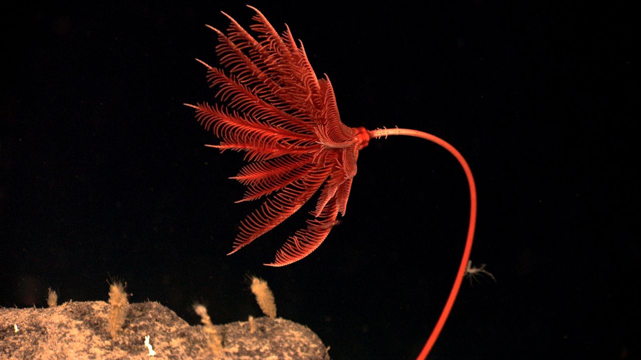
A sea lily, from the Gulf of Mexico. Organisms related to this one
were abundant in the sediments that became the summit
of Mount Everest. Photo: NOAA
Material from the Yellow Band has
shown that it too contains up to 5% crinoid fragments. Other fossil fragments were
found in the limestone: trilobites, brachiopods (lamp shells), and ostracods
(small shrimps). Below about 70 meters below the summit there is a layer that
formed from trapped sediment, 60 meters thick. The sediment was caught in a
biofilm, probably from cyanobacteria (algae). This kind of bacterial mat is
called a thrombolite, and forms in very shallow marine water. The thrombolite
bed forms the bottom of the summit pyramid, including the ‘third step’.
The highest rocks that have been brought
down were collected from 6 meters below the summit! They were collected in 1997
by a Japanese climber, M. Sawada; the analysis was published by Harutaka Sakai and collaborators. Two images from their
work with fossil fragments are shown here.

The left image shows a polished slab of the summit limestone. The
bar at the bottom is 1 centimeter. It shows bedding and faulting; fractures are
filled with calcite. On the right is an enlarged polished surface showing crinoid
and brachiopod fragments; the bar is 1 mm.

Left: grainstone with skeletal grains of
trilobite (T), crinoid (C), ostracod (O) and fecal pellets (P). The bar is 1mm.
Right: T trilobite fragments with the typical threefold arched shape. The bar
is 0.1mm.
The Tethys and
what really happened
How old are those fossil fragments? You might expect it to have the
age of the formation of the Himalayas: some 40 million years. But no. The fossils
are Ordovician to middle Cambrian, around 520 to 450 million years old. These
dates have been confirmed by analysis of zircon grains of the Yellow Band. The
sea floor, or rather the continental shelf, that became the summit of Everest
was ancient! It was much older than the mountains themselves. The sediment had
been on the sea floor for a very long time, before
India came and scooped it up.
There is something funny here. The Tethys Ocean first formed around
275 million years ago. That makes the ocean considerably younger than the age
of the fossils. Mount Everest couldn’t have come from
the Tethys! The fossils lived when the ocean wasn’t there
yet. The typical life time of an ocean is 200 million
years: by that time, the oceanic crust has cooled so far that it becomes denser
than the mantle below, and it begins to sink. A subduction zone forms which
swallows the ageing ocean. The difference in age between the fossils and the
Tethys correspond to this age. Mount Everest grew out of the previous
generation of ocean.
Indeed, before the Tethys formed,
there had been another ocean. Nowadays it is called the Paleo-Tethys. In those days,
of course, the world was so recent that many things lacked names, and in order to indicate them it was necessary to point. Originally, Gondwana
and Laurussia were separated by this Paleo-Tethys.
Around 290 million years ago, a fault developed in Gondwana. It became
a spreading ridge and experienced intensive flood basalt eruptions. The area to
the north of the spreading centre split off from
Gondwana. It was a fairly thin, long fragment, consisting
of Turkey, Iran, and Tibet. Behind them, the spreading ridge quickly became an
ocean: this is what became the Tethys (sometimes called the Neo-Tethys). The
flood basalt was carried with: the remnants can be
found as the Panjal Traps in Kashmir. The cause of
this early split of Gondwana is disputed. There is no strong evidence for a
mantle plume. It may have been an older, passive fault which became activated
when the old Paleo-Tethys began to subduct, and started
to pull on Gondwana.
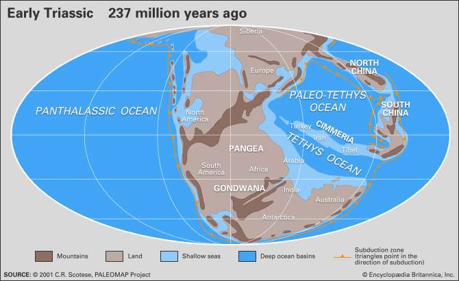
The fragment that included Tibet moved towards Asia, in the process
closing the Paleo-Tethys ocean in front and opening the Tethys ocean behind it.
200 million years later, the process replayed itself. Again
a subduction zone had formed as the Tethys was reaching the end of its life. Again Gondwana spit, this time terminally. India declared
independence and started its journey towards Asia, chasing after Tibet.
The collision now occurred in stages. First, the remnants of the
Tethys were swept up as the fragment of Tibet was driven into Asia. This formed
the first mountain range, the Trans-Himalayas, around 55 million years. The range
is still there: it lies north of the high Himalayas, starting from Kasmir. It runs parallel to it for over 1500 kilometers, with
peaks over 7 kilometers high. The range lacks the clear structure of the river valleys
of the high Himalayas. This is because it formed first, before the rivers were
there. The rivers began to flow from the range, including the Indus.
Immediately to the south, the Tethys-Himalayas were also uplifted. This included
the old sea floor. The process here was gentle, with little metamorphism.

Next, India arrived. This collision threw up the High Himalayas,
south of the Tethyan range. The Indus and Brahmaputra rivers were already there,
flowing from the Trans-Himalayas and through the Tethys-Himalayas. Both cut
through the newly rising mountains: you can see that they originate behind the
high mountains, showing that they predate it. The rising was a prolonged process.
The current high Himalayas were build
on granite emplaced around 20 million years ago. The rising of the high Himalayas
continued in phases, and is still on-going. India isn’t finished yet.

Source: wikipedia
The progressions of oceans is still seen
in the Himalayas. The shore of old Laurussia became the Trans Himalayans. The
continental shelf of the Paleo-Tethys was uplifted to form the Tethys-Himalayas.
The new shore line facing the Tethys ocean became the
High Himalayas, underplated by the Indian subcontinent.
So how did the Paleo-Tethys sediments end up on Everest? You may
blame the near-horizontal fault that runs between the limestone of the Qomolonga Formation and the Yellow Band. It provided a low-friction
contact. As the Trans Himalays rose
up, the limestone layer slid down, towards the south. When the High
Himalayas formed, the old Paleo-Tethys floor was ready and waiting. The
mountains formed underneath it, sediment from an ocean that had vanished in the
earlier collision.
Raising the roof
When you climb Mount Everest, you are not just reaching the summit
of Earth. It is also a journey back in time. The mountain is young, as mountains
go: the granite at its heart is no more than 24 million years old. One day,
erosion will have taken it down to the level of this granite. But not yet. For
now, remnants remain of the older surface that was here before the mountain
grew up. The fossils, microscopic and broken down they may be, show that this
surface is old as the mountains, by manner of speaking. They date back to the
Cambrian. The Indian Ocean is the grand child of the ocean in which they lived.
The fossils survived not one but two continental collisions.
The summit of Mount Everest is so much older than the mountain itself.
It was deposited when even Gondwana was young. Climbing Mount Everest takes you
to a time when life was young and many things lacked
names. Even if the fossils are only a millimetre across
– it is worth bringing some down, back to the sea where once they came from.
Albert Zijlstra, June 2018